


|
|
|
|
|
|
|
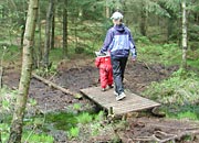
Vagleskogen OrienteeringEasy 4.5km orienteering loop, from end of March until end October, in undulating marsh and woodland surrounded by farmland. |
 |
|
| HOME page | BACK to previous page | |
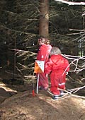 |
Orienteering
maps available from the Turist Forening (Tourist Board) in Stavanger. The
flags are moved to different positions at the end of June, giving an alternative
loop.
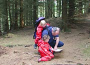
Great way to practise map reading skills and run steam off energetic kids who love chasing after the flags hidden in the trees to find the secret codes. Map reference: Kartblad 1212IV Stavanger, 096 233 By car: Drive south from Stavanger on the E39 and take the RV44 right towards Klepp. Vagleskogen is signposted to the left 2km south of Ganddal. Take care driving across the railway line! Parking: At entrance Distance from Stavanger: 22km |

advertise with us |
|
 |
|||
 |
Travel time from Stavanger:
25 minutes by car Duration of the visit: 1 hour or more Facilities: Car park Kids verdict: Great fun! See also: Vagleskogen Bogafjell Bogafjell Orienteering Hotels in Sandnes Hotel booking in the Stavanger area |
||

|
|||
| conditions of use |
© 2004 - 2024 Stavanger Travel AS All rights reserved |
about security |
| privacy policy | contact us |